
Identifying VMS targets across a 90 km² survey block with 3D IP–Resistivity
Canstar Resources & Canterra Minerals Corp, Buchans Project, Canada
The Buchans Project is located in central Newfoundland within a prolific volcanogenic massive sulphide (VMS) district best known for the historic Buchans mining camp. Between 1928 and 1984, more than 16.2 million tonnes were mined at exceptional grades, averaging 14.5% Zn, 1.3% Cu, 7.6% Pb, 126 g/t Ag and 1.37 g/t Au. The current Buchans Project covers approximately 106 km² and includes key stratigraphic horizons that host the original orebodies. Much of this prospective ground, along with adjacent claims held by Canstar Resources, remains underexplored at depth and along strike, making it well suited for modern, large-scale geophysical investigation.
Our approach – 3D Induced Polarization and Resistivity for disseminated and massive sulphide systems
Abitibi Geophysics completed a property-wide 3D IP/Resistivity survey over a ~90 km² block, with survey extents of approximately 14 km × 10 km. The survey was carried out using a 200 m station spacing to ensure both broad coverage and consistent resolution across the entire area. This large-scale layout was designed to detect deep, laterally extensive sulphide systems typical of VMS environments. The resulting dataset was inverted into a full 3D resistivity and chargeability model, allowing interpretation of geological trends, structural controls, and potential sulphide accumulations down to depths approaching 800 m.
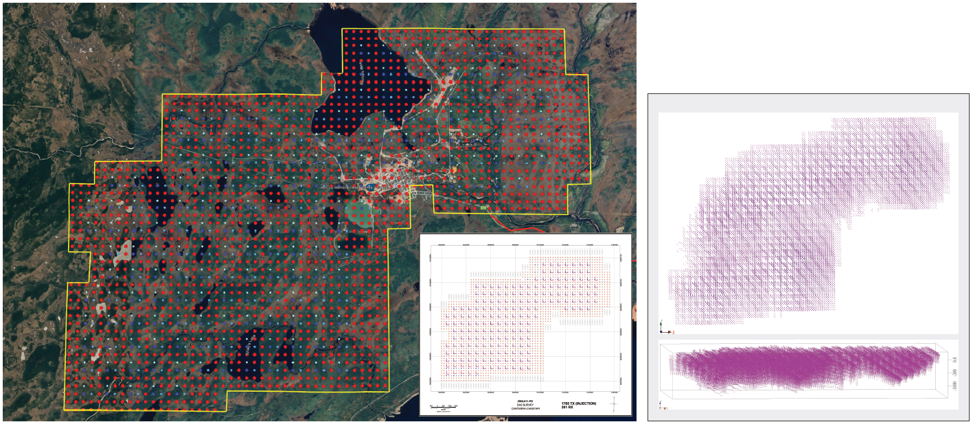
Survey coverage and design (left) and resulting 3D point cloud (right). Survey extents are approximately 14 km × 10 km; the total area covered is ~90 km².
Results
The 3D model resolved five large-scale anomalies characterized by low resistivity and high chargeability, spatially aligned with extensions of the known host stratigraphy. These features are compatible with sulphide mineralization similar in style and scale to the historic Buchans orebodies. The anomalies helped refine drill targets across the property and drilling in these areas confirmed both the depth and multi-kilometre strike, with intersections including 7.73 CuEq over 4.45 m. The property-wide dataset provided a comprehensive view of the subsurface, supporting ongoing exploration efforts by Canterra Minerals and Canstar Resources.
“The IP survey successfully delivered exactly what we were looking for: multiple, large-scale anomalies with geophysical signatures that mirror those of the historic, high-grade Buchans orebodies.”
— Chris Pennimpede, CEO, Canterra Minerals Corp.
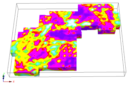
3D model of the recovered resistivity and chargeability distribution.


